Bibliography Background About KRIS
Stream Order in KRIS Projects
Leopold (1994) defines stream order as "a measure of the position of a stream in the hierarchy of tributaries." This relative guide to stream network classification came originally from Horton (1947) but was later modified by Strahler (1957). Stream order allows us to rank the size and potential power of streams. Orders range from small streams with no branches (1st Order) up to streams the size of the Mississippi River, which is a 10th Order. As two 1st Orders come together, they form a 2nd Order stream. Two 2nd orders converging form a 3rd Order. Streams of lower order joining a higher order stream do not change the order of the higher (see illustration).
Leopold (1994) cautions against using small scale maps for analysis, noting reduction in order when, for example, a U.S. Geologic Survey 1:100,000 map is used as opposed to the USGS 1:24,000 map. He also noted that the latter was still inadequate: "If actual channels are mapped on the ground, a far larger number will be found than those discerned on a published map." Hydrologists such as Horton (1947), Strahler (1957) and Leopold (1994), include intermittent steams when calculating stream order, but the California Department of Fish and Game does not (CDFG, 1998). When intermittent streams on the USGS 1:24,000 maps are eliminated, the result is a stream network representation that is actually less dense than that found on USGS 1:100,000 maps. This is demonstrated in the figures below.
Stream order discussions have bearing on the outputs of the Ecosystem Management Decision Support (EMDS) model, which CDFG uses in its North Coast Watershed Assessment Program. If stream orders are lower, CDFG lowers criteria for expected pool depth, which is a critical parameter for survival of juvenile coho and older age steelhead juveniles. This may lead to model outputs indicating suitable habitat when pools are filled in and, at best, marginally suitable for salmonids. By ascribing lower order to these streams, CDFG may attribute lack of pool depth to lack of flow and hydraulic energy. A more thorough analysis using the stream order generally recognized by hydrologists might lead to recognition of much greater stream power and other reasons for lack of pool depth, such as sedimentation.
 The KRIS project uses the best available stream data, which is based on USGS 1:24,000 maps, (shown at left) as prepared by the California Department of Forestry (CDF) Fire and Resource Assessment Program (FRAP) for use in the North Coast Watershed Assessment Program (NCWAP). This system does not leave out streams that show as intermittent on the topographic maps, which is consistent with Strahler (1957). The KRIS IFR team believes that this system best represents stream power for use in habitat typing analysis.
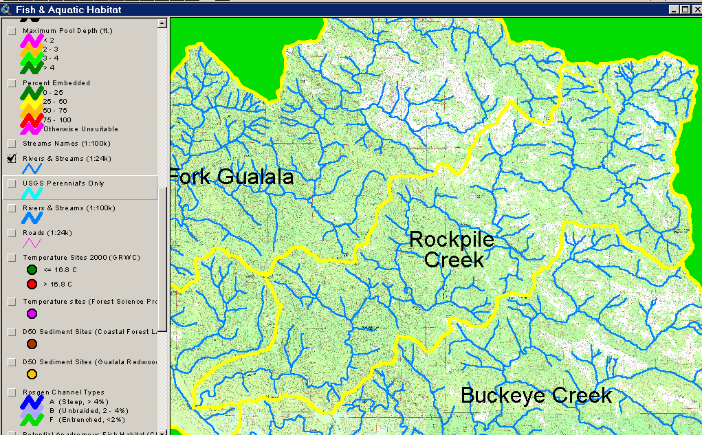
 This image shows the USGS 1:100,000 map of hydrology for Rockpile Creek in the Gualala River. Note that the stream network is much less dense than in the USGS 1:24,000 topographic map. If this hydrography is used to determine order, Rockpile Creek is a 3rd Order stream, while USGS 1:24,000 shows it as 4th Order.
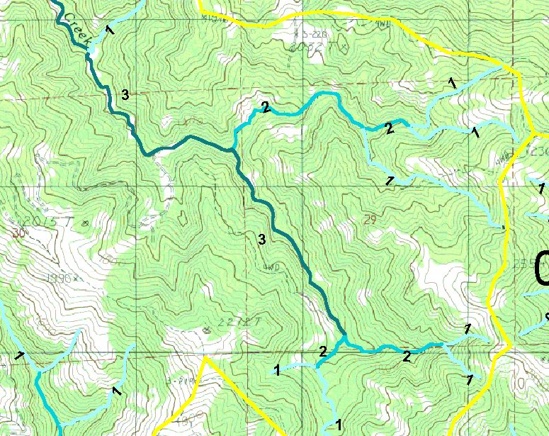
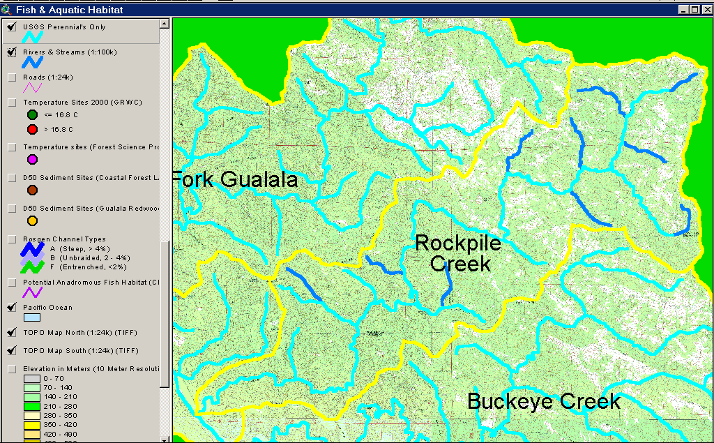
 The KRIS Gualala Map project shows Rockpile Creek as a 4th Order stream within just a few miles of its headwaters (at left). Many of the streams are overlain on dashed, as opposed to solid blue lines, which is the USGS convention for showing intermittent streams. It is recognized that the USGS 1:24,000 maps do not accurately reflect whether streams are actually intermittent or perennial (Leopold, 1994) and each of the tributaries adds power to the stream during winter flow. Consequently, the KRIS project retains them in consideration of stream order.
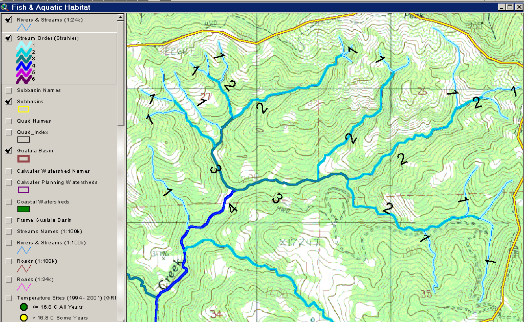
 The California Department of Fish and Game considers only solid blue line streams when determining stream order. The map image at left shows "perennial" tributaries of Rockpile Creek (solid blue lines) on the USGS 1:24,000 topographic map. This map image was made only for illustration here and is not found as a theme in the KRIS Gualala Map project. The KRIS IFR staff were not able to obtain electronic data for the hydrography CDFG used to determine stream order in the Gualala or EMDS model outputs which utilize them.
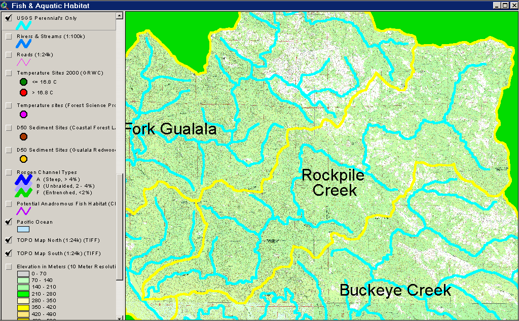
 The map image at left is the USGS 1:24,000 map showing only blue line streams (perennial) as used by CDFG with the 1:100,000 USGS map highlighted underneath. Dark blue lines indicate streams represented on the 1:100,000 map that do not appear on the CDFG stream map. The result of considering only perennial streams by CDFG results in a less detailed stream system in Rockpile Creek than the USGS 1:100,000 map. CDFG may have added streams for consideration of order, if they surveyed it and found it to have surface flow. The Gualala River Watershed Synthesis Report (CA Resources Agency, in review) does not explain how they arrived at stream order or what intermittent streams they may have found to be perennial in the field.
Cross Walk of Gualala Stream Orders from CDFG* and IFR
| Stream_Name | CDFG_Order | IFR_Order |
| Buckeye Creek | 3 | 4 |
| Danfield Creek | 1 | 2 |
| Doty Creek | 2 | 2 |
| Dry Creek | 1 | 4 |
| Dry Cr Trib | 1 | 2 |
| House Creek | 3 | 4 |
| Little NF | 2 | 3 |
| Little NF Trib | 1 | 2 |
| Log Cabin | 1 | 2 |
| McGann Creek | 1 | 2 |
| NF Gualala | 3 | 5 |
| Palmer Canyon Creek | 1 | 2 |
| Pepperwood Creek | 3 | 3 |
| Robinson Creek | 1 | 3 |
| Rockpile Creek | 3 | 4 |
| SF Gualala | 4 | 4 |
| Tombs Creek | 2 | 3 |
| Wheatfield Fork | 4 | 5 |
* Stream order data from CDFG provided in an Excel table by Karen Bromley of CDFG on 6/20/02.
References
California Resources Agency. In Review. Gualala River Watershed Synthesis. CA Dept. of Fish and Game, State Water Res. Control Bd., CA Dept. of Water Resources, CA Div. on Mines and Geology and CA Dept. of Forestry. Sacramento, CA. (See NCWAP website for access at http://www.ncwatershed.ca.gov/).
CA Department of Fish and Game. 1998. California Salmonid Stream Habitat Restoration Manual. Third Edition. Inland Fisheries Division. California Department of Fish and Game. Sacramento, CA. 495 p.
Horton, R.E. 1947. Erosional development of streams and their drainage basins: hydrophysical approach to quantitative morphology. Geological Society of America. Bulletin 56: 275-370.
Leopold, L.B. A View of the River. Harvard University Press. 1994.
Strahler, A.N. 1957. Quantitative analysis of watershed geomorphology. American Geophysical Union Transactions. 38: 913-920.