Bibliography Background About KRIS
Hypothesis 4: Dams are impeding recovery of Atlantic salmon in the Sheepscot river watershed.
Literature Foundation
It is widely known that dams restrict flow, limit fish passage, and alter the physical and chemical characteristics of a river (World Commission on Dams, 2000). In Maine, the National Academy of Sciences (NAS, 2003), concluded that the greatest impediment to Atlantic salmon recovery is the obstruction of passage and degradation of habitat caused by dams. The NAS (2003) also noted that dams on Maine's coastal watersheds account for 40% of the changes to water quality, 60% of habitat changes other than water quality, 85% of the passage problems, and 15% of the changes in predator/prey dynamics. (See page on Dams on Maine Atlantic Salmon Rivers also).
Dams create discontinuity within a river system (WCD, 2000). They can modify flow regimes, water temperatures, dissolved oxygen concentrations, turbidity, quality and quantity of food for aquatic organisms, and shift the upstream-downstream energy transfer within the watershed (Annear et al., 2004). Reservoirs formed by dams create environments that are more characteristic of a pond than a river, shifting biotic communities from a lotic environment to a lentic environment. Dams alter river hydrology by restricting natural flow processes, shifting flow peaks to which fish like salmon are accustomed (Netboy, 1974). Modifications to flow can also result in channel instability, increased bank erosion, bed degradation or aggradation, and simplification or modification of riparian or instream biota (Dunne and Leopold, 1978).
The reservoirs created by dams can often result in stratification that has a profound effect on water temperature and water quality (WCD, 2000). Because there is very little movement of the water in reservoirs, distinct thermal layers are created where warm water temperatures are found at the surface and much cooler temperatures are found near the bottom during summer. These warm water layers may be ideal habitat for nonnative introduced species, such as bass (NAS, 2003). An increased nutrient layer within the reservoir created by restricted downstream movement of sediments and organic matter can result in an increase in organic decomposition, consequently leading to reduced oxygen levels (NOAA & USFWS, 2004). Dams may also change nutrient cycling in a river, which can in turn have a profound impact on biota (Annear et al., 2004).
Anadromous fish represent a very important component of a rivers energy cycle as they transport marine derived nutrients all the way into the upper reaches of the watershed (Bilby et al. 1996 and 1998; Wipfli et al. 1998) and dams may impede this upstream flow of nutrients (WCD, 2003). Although most studies on the importance of salmon and terrestrial nutrient cycles are from the West Coast and pertain to Pacific salmon species, rivers in the Gulf of Maine likely derived similar benefits in energy transfer because of multiple anadromous species in addition to Atlantic salmon (see Fish Population Background page). On the River Bran in Northern Scotland, Nislow and Armstrong (in review) found that large stocking rates and low adult returns of Atlantic salmon caused a drain on the net phosphorous budget of the river and decreased primary production due to loss of marine-derived nutrients likely effects the entire ecosystem. Over time, the reduction of these marine-derived inputs may have the potential of creating a negative feedback loop, gradually depriving the system of its nutrients, and resulting in an overall decrease in stream productivity (Wipfli et al., 1998).
Sheepscot Literature and Data
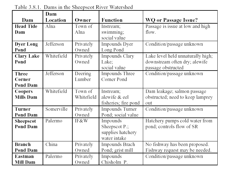
Over the course of history, there were 17 man made dams in the Sheepscot River that effectively blocked fish passage (Meister, 1982), but Halsted (2002) noted that a total of 42 dams still exist in the watershed today (see table). Four dams on the main branches of the Sheepscot River are recognized as potentially limiting fish passage and impacting both channel morphology and hydrology of reaches below. Arter (2004) described water quality problems assoicated with Sheepscot River dams, and expressed concern that several dams are barriers to migration for Atlantic salmon (see Table 3.8.1 from Arter).
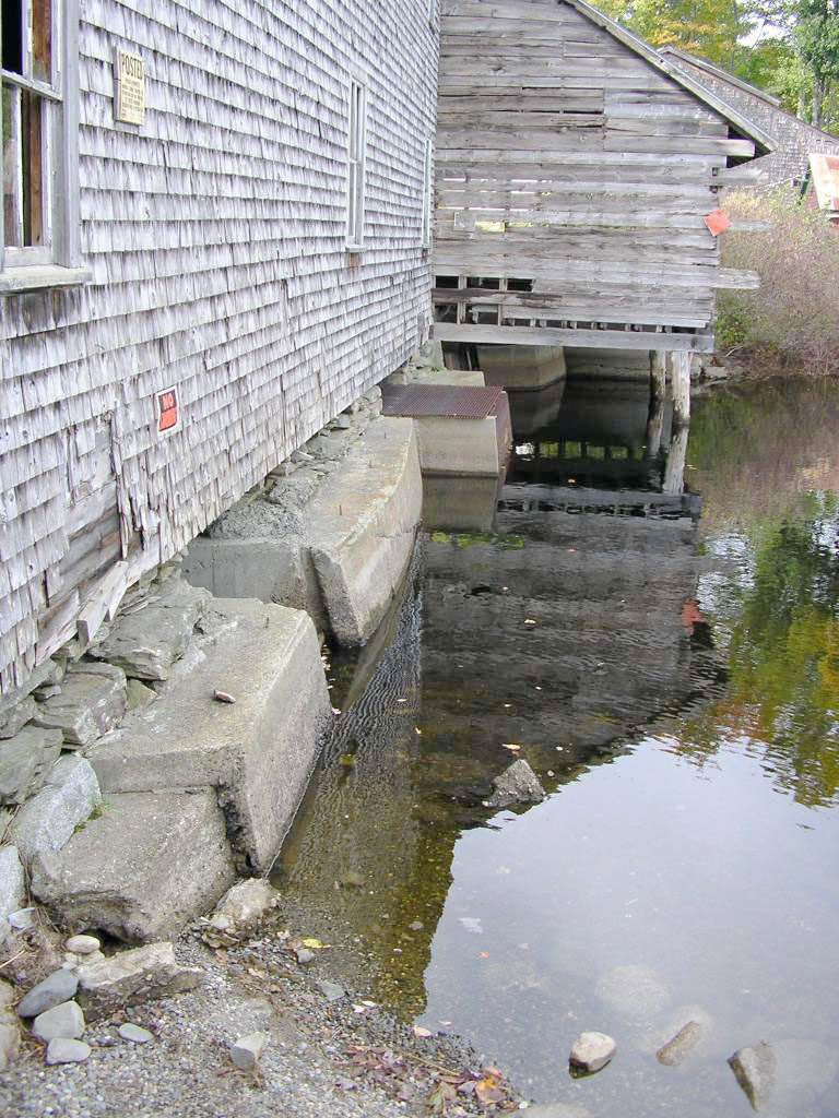
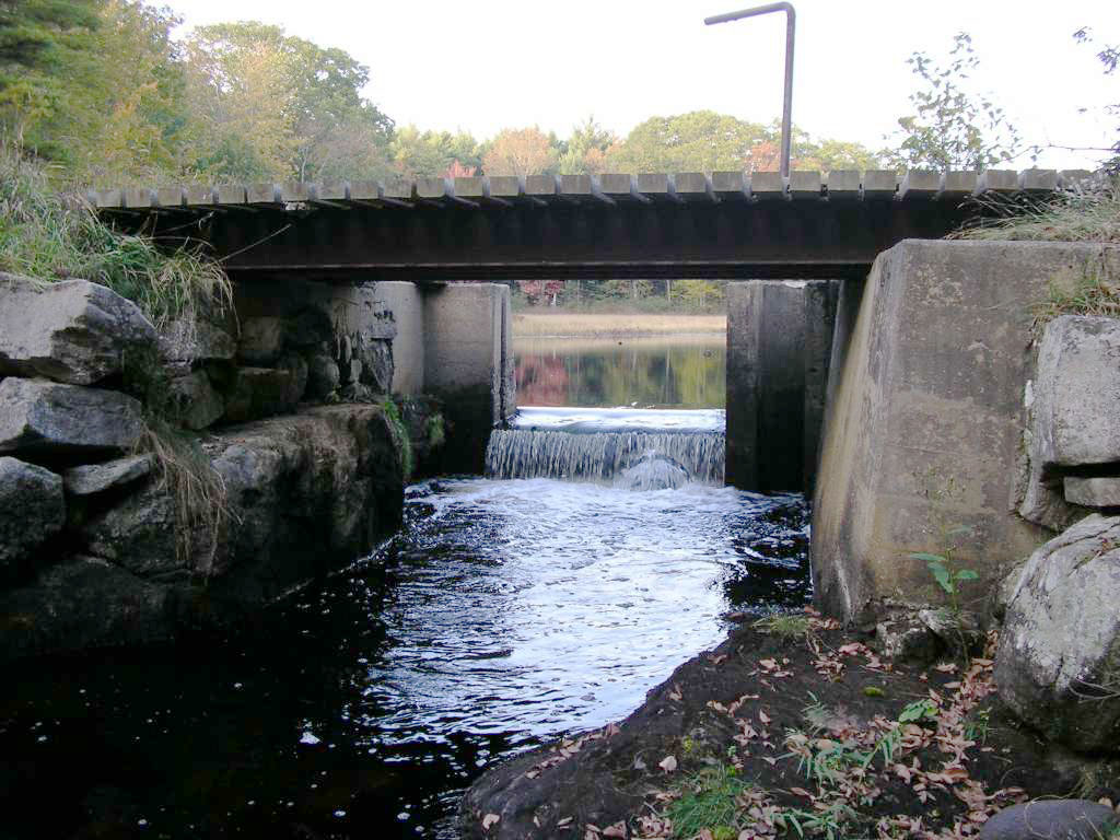
![Coopers Mills Dam. Click to enlarge [209 Kb]. Photo by Eli Asarian.](dam_coopers_ea_10_04.jpg) The Maine Atlantic Salmon Commission (MASC, 1997) noted that "Coopers Mills dam on the Sheepscot River may be restricting fish passage and thereby reducing available habitat." Coopers Mills is located approximately 14.5 km above head of tide (picture at left). The dam is 12 feet high, 185 feet long and made of stone and concrete with a denile fishway near the right bank. The dam is considered structurally unsafe and fish passage is often compromised due to leaks and cracks in the dam, and deteriorating flood gates that divert flow away from the fishway (NOAA & USFWS, 2004). Note water percolating through the dam at lower right in the photo. This dam creates an impoundment that is an extension of Long Pond, which favors warm water fishes (MDIFG, 1961).
The Maine Atlantic Salmon Commission (MASC, 1997) noted that "Coopers Mills dam on the Sheepscot River may be restricting fish passage and thereby reducing available habitat." Coopers Mills is located approximately 14.5 km above head of tide (picture at left). The dam is 12 feet high, 185 feet long and made of stone and concrete with a denile fishway near the right bank. The dam is considered structurally unsafe and fish passage is often compromised due to leaks and cracks in the dam, and deteriorating flood gates that divert flow away from the fishway (NOAA & USFWS, 2004). Note water percolating through the dam at lower right in the photo. This dam creates an impoundment that is an extension of Long Pond, which favors warm water fishes (MDIFG, 1961).
An offer from Trout Unlimited to assist with removal or further modification of Coopers Mills dam in the mid-1990's was rejected because of public concerns related to an existing alewife fishery at the dam and water supply for a hydrant. Trout Unlimited (Jeff Reardon, personal communication) is nearing completion of a study to evaluate the dam and related hydrologic factors in order to help formulate options to remove or repair the dam or otherwise improve fish passage, as well as meet other community needs.
![Headtide Dam. Click to enlarge [220 Kb]. Photo by Eli Asarian.](dam_headtide_ea_10_04.jpg) The Head Tide Dam (at left) is the lowest on the Sheepscot, located just above the top of tidal influence in the town of Alna. Bryant and Fletcher (1951) initiated studies to remedy fish passage and in 1952 the dam was modified to allow fish passage for salmon and alewives. Meister (1982) noted that the dam was not effectively breached until 1968 when a small hole was made in the dam near the river left abutment. NOAA and USFWS (2004) stated that, although Head Tide Dam was allowing fish passage, it was changing Atlantic salmon habitat. Arter (2004) shared the concern regarding habitat changes at Head Tide and at Coopers Mills Dam, which are both "run of the river" type dams, but also suggested that Head Tide Dam may still partially impede Atlantic salmon migration during some periods. This photo, taken in October 2004, shows low flow conditions that might impede passage of adults or juvenile Atlantic salmon.
The Head Tide Dam (at left) is the lowest on the Sheepscot, located just above the top of tidal influence in the town of Alna. Bryant and Fletcher (1951) initiated studies to remedy fish passage and in 1952 the dam was modified to allow fish passage for salmon and alewives. Meister (1982) noted that the dam was not effectively breached until 1968 when a small hole was made in the dam near the river left abutment. NOAA and USFWS (2004) stated that, although Head Tide Dam was allowing fish passage, it was changing Atlantic salmon habitat. Arter (2004) shared the concern regarding habitat changes at Head Tide and at Coopers Mills Dam, which are both "run of the river" type dams, but also suggested that Head Tide Dam may still partially impede Atlantic salmon migration during some periods. This photo, taken in October 2004, shows low flow conditions that might impede passage of adults or juvenile Atlantic salmon.
The two other remaining dams recognized as having substantial potential to block Atlantic salmon migration are at the outlets of Branch Pond near the headwaters of the West Branch, and Sheepscot Lake which lies in the upper Sheepscot and East Branch watersheds (see map below). The dam at Sheepscot Lake does have a fish ladder, though for a period of time up until 2004 the fishway was installed backwards in an attempt to exclude alewives from entering Sheepscot Lake (Jed Wright, personal communications). Prior to 2000 the fishway was often closed at least part of the year to exclude lamprey passage into the lake (Kircheis, 2004). The dam at Branch Pond does not have fish passage, denying all fish species upstream access into Branch Pond.
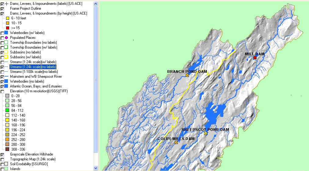 This map of the upper Sheepscot River watershed and headwaters of the West Branch shows dam locations and color coded heights as well as lakes and ponds. While the dam at the outlet of Branch Pond is higher (10-15 ft.) than the one at the outlet of Sheepscot Pond (6-10 ft.), the latter creates a larger impoundment.
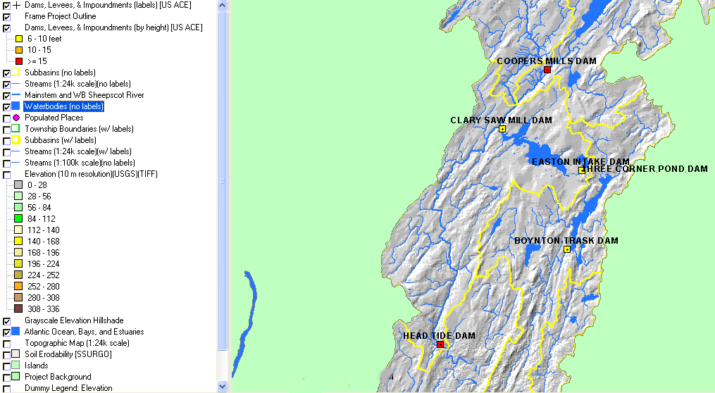 The lower Sheepscot River is shown here with mainstem dams and their heights displayed. Coopers Mills Dam is at the outlet of Long Pond on the mainstem Sheepscot as is Head Tide Dam near Alna, which is shown at the lower left of the map. At the Head of Tide, high flows can create velocities through the breach that are too strong to pass most allosids and small resident fish such as cyprinids or juvenile salmonids. At Coopers Mills Dam, lack of maintenance of the dam and the fishway has made the fishway impassible during low flow periods when no water flows through the fishway. It may also delay passage during high flow periods because of a loss of fishway attraction as fish are diverted to the high flows going through the deteriorated flood gates on the opposite shore. In recent years, these two dams have been managed to reduce passage of alewives and lampreys because of concerns that these species may interfere with the recreational fisheries in Sheepscot Lake. The Dyer River, shown at middle right on the map, also has a mainstem dam, although it is unknown whether it presents fish passage problems for Atlantic salmon (Arter, 2002).
 This photo shows the old abandoned mill that sits on top of the dam at the outlet of Branch Pond at the headwaters of the West Branch Sheepscot River. This dam has no fish passage facilities.
The dam at the outlet of Dyer Pond on the Dyer River is shown at right. This is a lower Sheepscot River tributary and the dam is near its headwaters. It is not currently recognized as impeding Atlantic salmon migration, but the low gradient of the Dyer River would have likely allowed historic production in this reach.
Relationship to Other Hypotheses (Potential Casual Mechanisms)
Hypothesis #1: NAS (2003) indicates that dams are the greatest limiting factor to Atlantic salmon recovery. That dams have limited the species in the Sheepscot basin is well established by historic (Bryant and Fletcher, 1951; Foye, 1967; Meister, 1982) and recent (MASC, 1997; NOAA & USFWS, 2004) literature.
Hypothesis #2: Arter (2004) notes the relationship of dams to stream warming, particularly in the Sheepscot River reach below Coopers Mills Dam and Long Pond. There is likely a connection between impoundments and stream warming resulting from pond limnology and flow depletion (Arter, 2004).
Hypothesis #3: The channel morphology of the Sheepscot River and its ability to support Atlantic salmon are both impacted by dams. Some river reaches are submerged by reservoirs and become more suitable for warm water species than salmonids. Gravel supply needed for spawning substrate and large wood recruitment for increased habitat complexity may be impeded by dams.
Hypothesis #6: There is a clear link between impoundments in the Sheepscot River watershed and proliferation of nonnative fish that compete with and predate upon Atlantic salmon (Bryant and Mahoney, 1950; Meister, 1982).
Alternate Hypothesis: Sheepscot River fish passage problems related to dams have been remedied and other dam related problems can be remedied sufficiently to recover Atlantic salmon.
Atlantic salmon only use portions of the Sheepscot River watershed and fish passage problems at key dams, such as Head Tide and Coopers Mills, have been addressed sufficiently to allow passage. While impoundments may favor warm water species in summer, the range of Atlantic salmon does not extend upstream of many major impoundments, thus limiting the effects of competition and predation from introduced species. Warming of reservoirs above dams in summer may negatively affect salmon, but reaches below dams are also kept free of anchor ice, which benefits winter rearing. Factors other than dams are limiting Atlantic salmon production.
Monitoring Trends to Test the Hypotheses
Removing a dam and monitoring limnological and biological response would be a way to test whether Atlantic salmon would rebound in response. Factors that would need to be monitored in addition to fish standing crops would be cross sectional profiles, gravel size (D50), fine sediment in spawning gravels, water temperatures and benthic macroinvertebrates. Fish studies should include all species because dam removal may change the fish community structure, favoring salmonids and reducing the number of warm water species.
Computer modeling could be used to determine how the dams affect water temperature. It is likely that additional water temperature data would need to be collected to put into the model, but modeling temperatures in rivers and lakes is a long-established practice that can produce accurate results if done properly. Once the model is developed and calibrated, various scenarios could be modeled and results examined. Examples of scenarios include changes in riparian vegetation, changes in water withdrawal, and dam removal.
References
Annear, T., I. Chisholm, H. Beecher, A. Locke, P. Aarrestad, C. Coomer, C. Estes, J. Hunt, R. Jacobson, G. Jobsis, J. Kauffman, J. Marshall, K. Mayes, G. Smith, C. Stalnaker, and R. Wentworth. 2004. Instream Flows for Riverine Resource Stewardship (revised edition). Instream Flow Council, Cheyenne, Wyoming. http://www.instreamflowcouncil.org/justreleased.htm
Arter, B. S. 2004. Sheepscot River Water Quality Monitoring Strategic Plan: A guide for coordinated water quality monitoring efforts in an Atlantic salmon watershed in Maine. Prepared for the Project SHARE: Research and Management Committee. 84 pp. [975kb]
Bilby, R.E., Fransen, B.R., and Bisson, P.A. 1996. Incorporation of nitrogen and carbon from spawning coho salmon into the trophic system of small streams: evidence from stable isotopes. Can. J. Fish. Aquat. Sci. 53:164-173.
Bilby, R.E., Fransen, B.R., Bisson, P.A., and Walter, J.K. 1998. Response of juvenile coho salmon ( Oncorhynchus kisutch) and steelhead ( Oncorhynchus mykiss) to the addition of salmon carcasses to two streams in southwestern Washington, U.S.A. Can. J. Fish. Aquat. Sci. 55:1909-1918.
Bryant, F. G. and J.V. Mahoney. 1950. West Branch of the Sheepscot River stream survey. Memo file cards containing information. U.S. Fish and Wildlife Service, Atlantic Salmon Investigations for the Maine Atlantic Sea Run Salmon Commission. Bangor, ME. 53 pp. 3.5Mb**
Bryant, F. G. and J.S. Fletcher. 1951. A report on the Head Tide, (Jewett's), and King's Mill Dams and other obstructions on the Sheepscot River with recommendations for providing for adequate passage of salmon and other fish. U.S. Fish and Wildlife Service, Atlantic Salmon Investigations. 6 pp. 25kb**
Danie, D.S., J. G. Trial, and J. G. Stanley. 1984. Species profiles: life histories and environmental requirements of coastal fish and invertebrates (North Atlantic) -- Atlantic salmon. U.S. Fish Wildlife Service.. FWVOBS-82/11.22. U.S. Army Corps of Engineers, TR EL-82-4. 19 pp. [500kb]
Dunne and Leopold. 1978. Water in Environmental Planning. WH Freeman an Company, New York.
Foye, R.E. 1967. Maine Rivers: the historical Sheepscot. Maine Department of Inland Fisheries and Game. 9(2): 8-11.
Halsted, M. 2002. The Sheepscot River, Atlantic Salmon and Dams: A Historical Reflection. SVCA, Alna, MA. 36 p
Kircheis, D. 2004. [currently incomplete citation]
Meister, A. L. 1982. Sheepscot: An Atlantic salmon river management report. Atlantic Sea Run Salmon Commission. Bangor, ME. 47 pp. [3.7Mb]**
National Marine Fisheries Service (NOAA) and U.S. Fish and Wildlife Service (USFWS). 2004. Draft Recovery Plan for the Gulf of Maine Distinct Population Segment of Atlantic Salmon (Salmo salar). National Oceanic and Atmospheric Administration, NMFS, and Northeastern Region USFWS. Silver Spring and Hadley, MA. 239 pp. [950 kb]
National Oceanic and Atmospheric Administration (NOAA). 2004. Anadromous Fish and Dams. NOAA National Marine Fisheries Service website. U.S. Dept of Commerce. http://www.nmfs.noaa.gov/habitat/habitatprotection/anadromousfishdam.htm
National Research Council. 2003. Atlantic Salmon in Maine. Committee on Atlantic Salmon of Maine, National Research Council, National Academy of Sciences, National Academy Press, Washington D.C. [3.5Mb]
Netboy, Anthony. 1974. The Salmon: Their Fight for Survival. Houghton Mifflin Company, Boston, MA. 319 p.
Nislow, K.H., Armstrong, J.D and McKelvey, S. 2004. Phosphorus flux due to Atlantic salmon (Salmo salar) in an oligotrophic upland stream: effects of management and demography. Can. J. Fish. Aquat. Sci./J. Can. Sci. Halieut. Aquat. 61(12): 2401-2410 Abstract available at: http://pubs.nrc-cnrc.gc.ca/cgi-bin/rp/rp2_abst_e?cjfas_f05-006_61_ns_nf_cjfas
Reardon, Jeff: Trout Unlimited Northeast Region Coordinator. Personal communication.
Wipfli, M.S., Hudson, J.P., Chaloner, D.T., and Caouette, J.P. 1999. Influence of salmon spawner densities on stream productivity in southeast Alaska. Can. J. Fish. Aquat. Sci. 56:1600-1611.
World Commission on Dams. 2000. Dams and Development. Earthscan Publications Ltd. London, G.B. and Sterling, VA, USA. http://www.dams.org/report/