Bibliography Background About KRIS
Hypothesis #3: Lack of aquatic habitat complexity has contributed to the decline of Atlantic salmon in the Sheepscot River watershed.
This hypothesis is framed around the assumption that a suite of changes with variable time periods have degraded physical habitat in the Sheepscot River for Atlantic salmon. These conditions include increased sedimentation, stream channel alterations, changes in riparian vegetation and lack of recruitment of large woody debris. Because data specific to the Sheepscot River on these parameters is not robust, there is a section on data gaps that, if filled, would provide more definitive information on physical habitat quality as a limiting factor on Atlantic salmon.
Literature Foundation
For the sake of clarity, literature foundation for different subject areas related to channel complexity and aquatic habitat diversity (sediment, large wood, channel form and riparian) are separated within this section. The Sheepscot River was identified by Whiting (2002) as "the river most affected by land-based human activities" of Gulf of Maine DPS Atlantic salmon rivers.
Sediment Related Habitat Problems
The Sediment and Atlantic Salmon Habitat Background page provides a summary of literature on how sediment affects Atlantic salmon. Sediment contributed to streams over the natural equilibrium can be very detrimental to salmonid habitat, clogging spawning gravels, filling pools, elevating turbidity, changing channel form and causing increased bedload mobility (Frissell, 1992). Several studies have documented the relationship between permeability and Atlantic salmon survival during egg incubation and through fry emergence (Peterson, 1978; McCrimmon and Gotts, 1986). Permeability is reduced when fine sediments are deposited in stream beds, which can lead to lower dissolved oxygen rates and greater concentrations of metabolic wastes around incubating eggs (Barnard and McBain 1994). In Maine, several studies have found similar trends for both natural and artificially created redds. Gustafson-Marjanen (1982) and McKenzie (1985) found permeability was related to emergence from wild redds in several Downeast rivers. While these studies are somewhat limited in sample size, they support the hypothesis that permeability has a significant affect on survival to emergence of salmon, including Atlantic salmon in Maine. The Maine Atlantic Salmon Commission has begun further studies to estimate permeability in spawning areas on Downeast Rivers and will begin relating salmon survival to permeability (Sheller, 2005).
Mills (1981) noted that juvenile Atlantic salmon utilize pool habitat; consequently, carrying capacity for the species is diminished when pools are filled by sediment. Adult salmon need to have pools for holding within 800 meters of the spawning grounds in order to be able to hide and rest (Armstrong et al. 2003; Bardonnet and Baglinière 2000). McLaughlin and Knight (1987) found that optimal pool depth for holding adults was between 1.8-3.6 meters deep (6-12 ft.). Haines (1992) pointed out that channel alterations for drainage and flood control may reduce pool frequency and depth.
Fine sediment infiltrating coarse substrates is referred to as embeddedness and increased embeddedness may block juvenile salmon from seeking shelter beneath substrates (Sylte 2002). Recent studies on the Downeast rivers found indications that juvenile densities were inversely related to embeddedness levels (Atkinson et al. 2005), which is consistent with the findings of McCrimmon (1954 as cited in Danie et al, 1984) that deposition of sediments that clogged interstitial spaces decreased survival of Atlantic salmon fry and parr. Aquatic macroinvertebrates thrive in the interstitial spaces of gravel on the stream bottom, but this important food resource for Atlantic salmon if the substrate becomes embedded (Rosenau and Angelo, 2002).
Dill et al. (2002) noted that elevated turbidity can limit Atlantic salmon production by limiting the ability of juveniles to feed, but that the severity of the impact was proportionate to the duration of impairment. According to the National Academy of Sciences (NAS, 2003), sediment from roads is a major source of pollution in Maine Atlantic salmon rivers that is likely a significant limiting factor on salmon recovery.
Large Woody Debris
The Riparian Zones and Large Woody Debris Background page provides a summary of literature on the role of large wood in Atlantic salmon habitat. Large woody debris (LWD) may be important for Atlantic salmon during several life-history stages (NOAA/USFWS, 2004). Nislow et al. (1999) found that survival of salmon fry in small streams in Vermont was strongly correlated with the availability of lateral, low-velocity microhabitats, and that LWD addition increased the availability of these habitats. LWD may be even more important for older salmon parr that extensively use instream cover, particularly during winter when survival may be very low in streams lacking structure (Cunjak et al. 1998). This issue may be particularly relevant to Atlantic salmon in Maine where data collected from index stream sites indicate that there is a high mortality rate for large (pre-smolt) salmon parr during the winter prior to their outmigration as smolts, significantly affecting overall smolt production (Obedzinski, unpublished report). If pre-smolt winter survival is linked to the availability of appropriate habitat, increasing the amount of LWD cover may increase over-winter survival and smolt production.
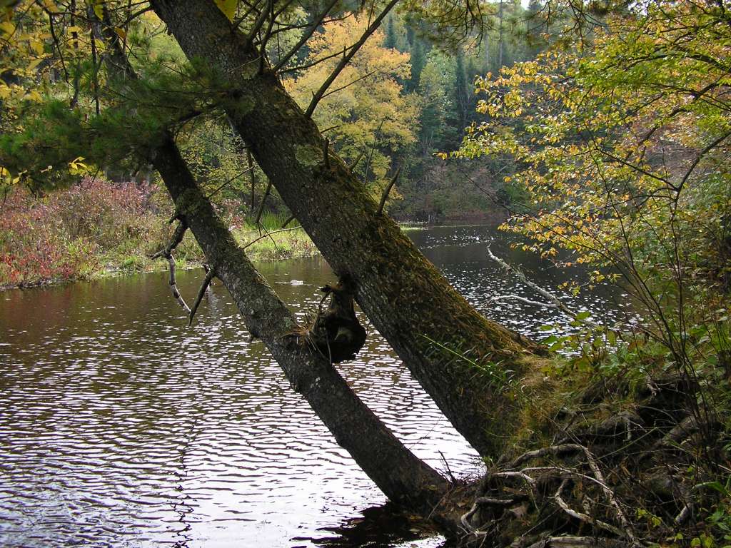 This photo shows a large streamside conifer leaning out over the upper Sheepscot River channel, which will likely contribute long lasting large wood, when it falls into the channel. Such mature conifers stabilize banks and their root masses provide cover for juvenile salmonids, particularly if the bank becomes undercut. Unfortunately, this is a rare rather than representative riparian condition.
Stream Channel Alteration and Riparian Function
Haines (1992) noted that diking or draining activities routinely associated with agricultural development may have substantially altered stream morphology in New England Atlantic salmon rivers. Channels with larger width to depth ratios tend to heat (Poole and Berman, 2001) and cool (Cunjak et al. 1998) more quickly than narrow, deep channels. Changes in channel geometry could also increase embeddedness as wider channels could decrease bed mobility (Montgomery and Buffington, 1993). In coastal Maine Rivers and associated riparian areas, the greatest amount of human disturbance occurred between 50 to 250 years ago, depending on the location in the river (Laser, 2005). Inland areas were not settled as rapidly as coastal areas, particularly along smaller rivers and tributaries that were not easily navigable. Although few records exist that describe the landscape prior to settlement, it is known that rivers were viewed as sources of water power or transportation, and in most areas riparian forests have been harvested multiple times (Laser, 2005). Log drives occurred on even the smallest of streams (Allin and Judd, 1995) and structural elements such as large wood or boulders were removed to facilitate the passage of log rafts downstream.
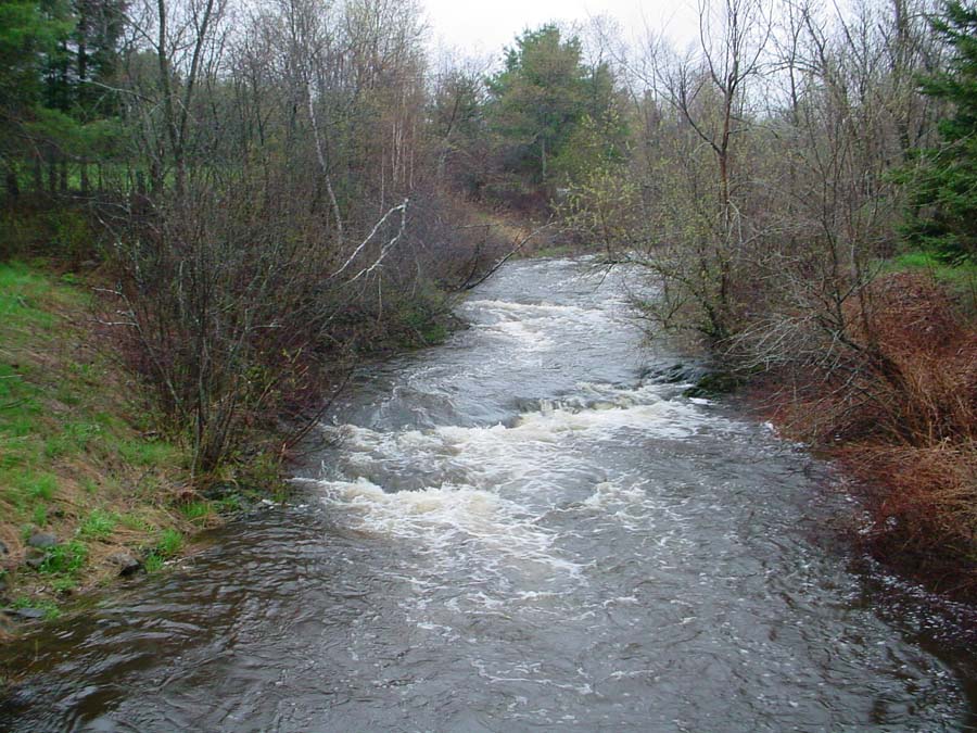
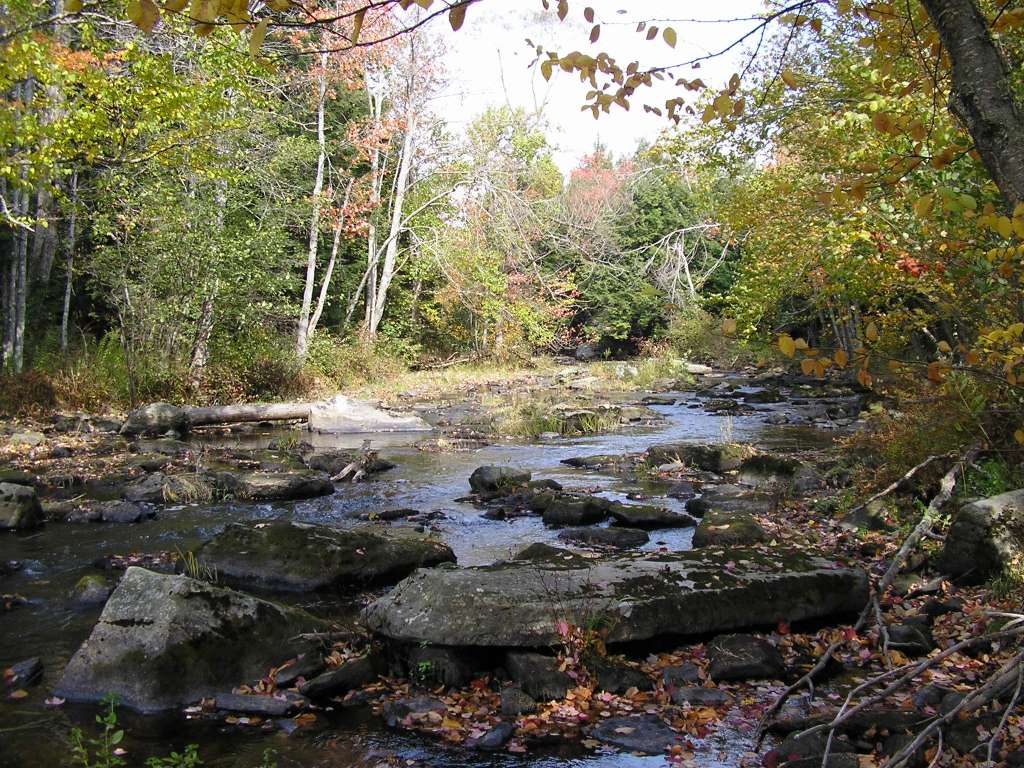 Sedell et al. (1988) documented beneficial effects of large wood in bedrock reaches of Pacific salmon streams. In old growth or climax forest setting, large wood jams trap spawning gravels and form pools that slow the flow of nutrients and provide rearing habitat for juvenile fish and holding pools for returning adults. The net effect is much more complex aquatic habitat with much higher carrying capacity than a bare bedrock (Sedell et al., 1988). Much of the landscape of Maine was created by the erosional force of glaciers, which scrapped away the mantle of soil in many places leaving only bedrock. The picture at left of the upper Sheepscot River shows a stream reach with exposed bedrock, little LWD and a riparian zone in early seral conditions.
Sheepscot River Specific Information
Sediment Related Habitat Problems
Sediment sources on the Sheepscot River are numerous (KSWCD, 2003). Recent inventories have identified over 400 NPS sites on the Sheepscot River (Steve Koenig personal communication)(see Map). NPs sources include faulty culverts, poor road ditching, road runoff, bank erosion and unstable shoulders. Dill et al. (2002) postulate that increased turbidity was due to Sheepscot River road densities, which are very high when compared to other DPS Atlantic salmon rivers.
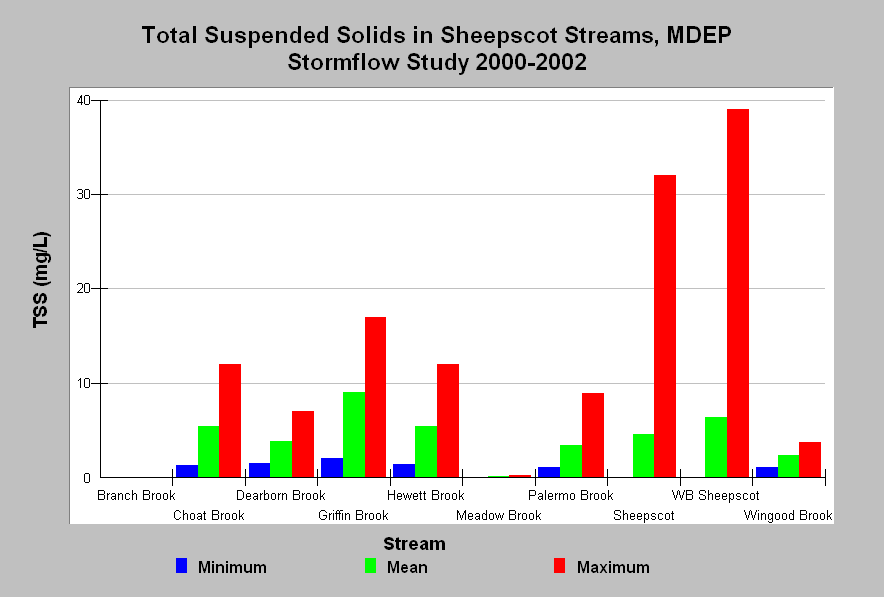 This chart shows the minimum, mean, and maximum turbidity concentrations measured during the Maine Department of Environmental Protection WQM Program's 2000-2002 stormflow study. Whiting (2002) notes that according to Newcombe and Jensen (1996), these TSS values will cause at least short-term reductions in feeding rates for salmon parr. TSS levels that remain over 20 mg/L for 24 hours can cause minor physiological stress, with moderate physiological stress resulting from 48-hour exposure (Newcombe and Jensen (1996), but the number of samples in the MDEP Sheepscot dataset is not high enough to precisely determine the duration of exposure. Turbidity data from the same dataset show a similar pattern as TSS.
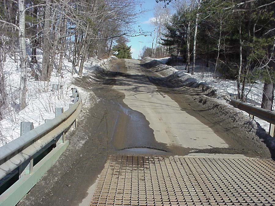 This is a photo of the Howe Road from the bridge during a spring melt event. The amount of sand is apparent on the snow banks. Although there has been no quantitative assessment of the impacts of sediment on the river and its tributaries, numerous sources of sediment have been identified in the watershed (KSWCD, 2003).
Large Woody Debris
Sheepscot River specific habitat surveys conducted through the 1990s recorded the presence of LWD within habitat features (MASC, 2000). The data indicate that, in channels less than 10 meters wide, 75% of pool, run and riffle habitat features on the Sheepscot River lack LWD. A 10 meter channel width is used as a threshold as larger channels would be less likely to retain LWD due to higher flows and the absence of trees with channel spanning heights. The chart at left shows the percentage of all habitat units that contain woody debris.
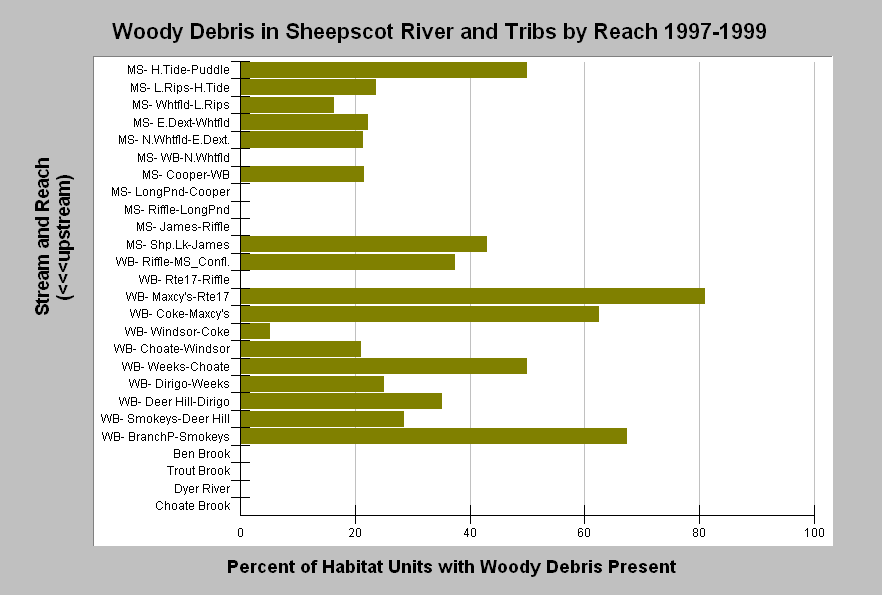 This chart shows the percentage of habitat units in each reach where surveyors noted the presence of woody debris. Surveys were conducted in the Sheepscot River and its tributaries during 1997-1999 by the Maine Atlantic Salmon Commission and U.S. Fish and Wildlife Service. Habitat units where surveyors did not note whether or not woody debris was present were excluded from this calculation. Streams in the chart are grouped by stream and sorted in upstream order. In reach names, MS is mainstem Sheepscot and WB is West Branch Sheepscot (see Chart Table of page for complete key to reaches). Also see Map of survey locations.
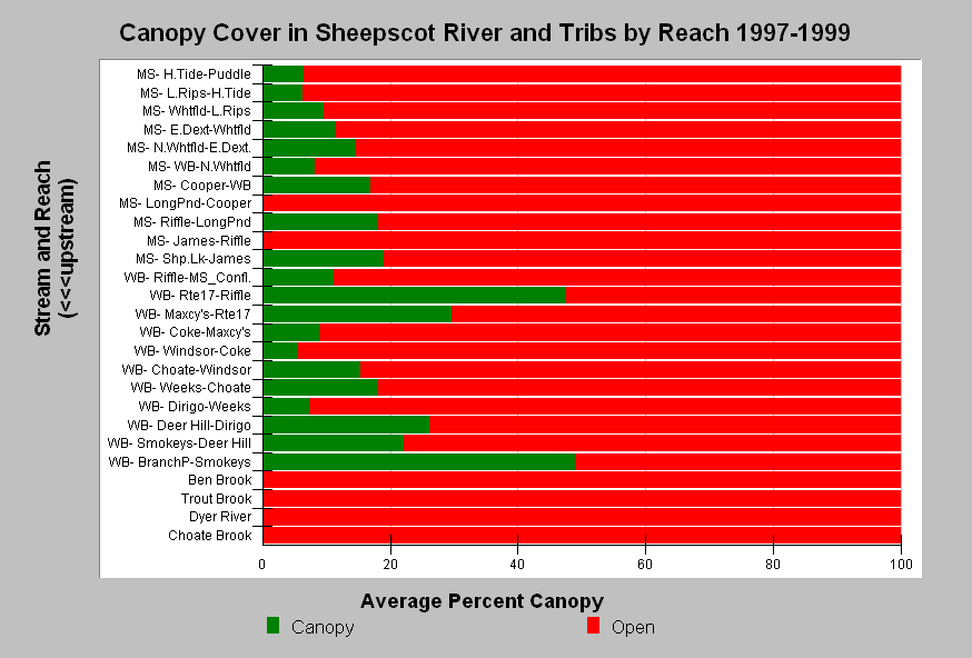 This chart shows the canopy density in all surveyed reaches in the Sheepscot River and its tributaries as recorded during 1997-1999 habitat surveys by the Maine Atlantic Salmon Commission and U.S. Fish and Wildlife Service. Streams in the chart are grouped by stream and sorted in upstream order. The data indicate low canopy closure in the Sheepscot River and its tributaries. This may reflect early successional riparian conditions, where bank vegetative cover is fairly high (SRWC, 2000), but canopy height insufficient to fully shade the stream and trees likely to small to contribute long-lasting LWD. Also see Map of survey locations.
Compared to other Maine Atlantic salmon DPS rivers, the Sheepscot has low canopy closure (see Chart).
 This photo shows the West Branch Sheepscot River near Weeks Mills. Laser (2005) points out that, although riparian zones in the Sheepscot basin have been in recovery, they are largely in early seral stages and likely more dominated by hardwoods than original stand conditions. Hardwoods and younger conifers lack longevity when they fall into streams in comparison to mature conifers and are less likely to be recruited to streams by natural events such as ice or wind storms (Laser, 2005).
Stream Channel Alteration and Riparian Function
There is an extensive catalog of changes in physical habitat on the Sheepscot River. The coastal portion of the watershed was settled in the 1600s, but areas above the head of tide were not settled until the early 1800s due to ongoing conflicts between the French, English, and Indigenous people in the region (Halsted, 2002). The large patent holders in the Sheepscot River basin, the Waldo and Kennebec Patents, were interested in improving their holdings by clearing forests for farming (Laser, 2005). The proprietors of the patents began surveying the towns in the late 1790s to early 1800s to encourage settlers to begin "taming" the landscape (Grow 1975). It is the legacy of this taming of the land that influences the Sheepscot River today. Disturbance due to agriculture was waning in the 1950s (see Chart), but Bryant and Mahoney (1950) still found numerous areas that lacked any riparian vegetation and where there was active bank erosion. Many reaches within the Sheepscot River display large width to depth ratios (Laser, 2005), which may be a legacy of cumulative channel and riparian alteration. Arter (2004) noted significant local modifications to the channel adjacent to the Palermo hatchery.
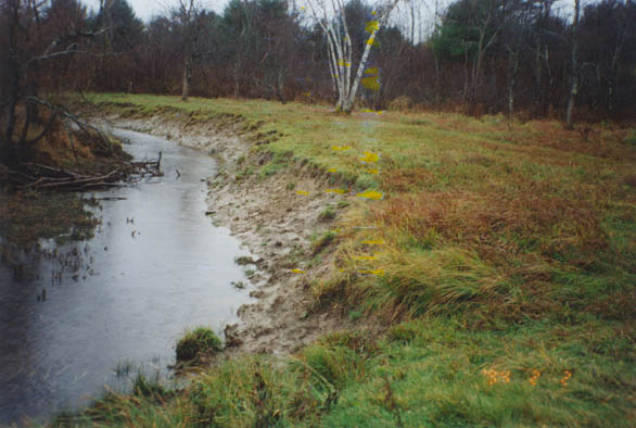 This is a tributary to the Sheepscot River with an eroding bank at a livestock watering access point. These types of sites are not common today (SRWC, 2000) and this location is slated for restoration, however, these conditions were probably more widespread in 1950 and earlier. This condition represents a potential source of sediment to the stream, resulting in habitat degradation, but also demonstrates how lack of riparian integrity can lead to loss of bank and channel stability.
Relationship to Other Hypotheses (Potential Casual Mechanisms)
Hypothesis #1: The cause for the reduction of Atlantic salmon in the Sheepscot River in both numbers and abundance may be changes in freshwater habitat as well as impediments to migration caused by dams.
Hypothesis #2: Elevated summer water temperature is identified as a factor limiting Atlantic salmon recovery in the Sheepscot River by this hypothesis. Channel widening, loss of depth or changes in riparian conditions may all influence water temperature.
Hypothesis #4: Dams not only block fish passage but also alter channels and potential Atlantic salmon habitat. Reaches above dams are submerged and create lacustrine habitat to which salmon may be less suited. Dams also block sediment transport and change flow regimes disrupting spawning gravel supply, altering channel morphology and sometimes leading to riparian alteration, which may all be detrimental to Atlantic salmon habitat and carrying capacity.
Hypothesis #6: This hypothesis suggests that introduced species of fish are limiting Atlantic salmon recovery due to both competition and predation. If Sheepscot River channels are wider, warmer and less complex than they were historically, that may provide a competitive advantage for warm water species that compete with or predate upon Atlantic salmon.
Alternate Hypothesis: Aquatic habitat is not limiting Atlantic salmon in the Sheepscot River watershed.
Sediment: Sheepscot River channels are naturally wide, pool frequencies naturally low and high embeddedness is not related to anthropogenic actions. Current conditions are similar to historic conditions and other factors are limiting Atlantic salmon recovery.
Large Woody Debris: Sheepscot geomorphology is diverse with bedrock and glacial deposit controls, and LWD would have played a limited role in shaping channel geometry and was not an important part of shaping Atlantic salmon habitat.
Stream Channel-Riparian Condition: While some anthropogenic activities may have impacted the channel, features such as over-widended channels are a function of bedrock geology. Riparian conditions are in advanced recovery and are not contributing to conditions limiting Atlantic salmon recovery.
Monitoring Trends to Test the Hypotheses/Plugging Data Gaps
Sediment Related Habitat Problems: There is insufficient data at present to accept or reject the hypothesis that sedimentation is limiting Atlantic salmon in the Sheepscot River at any life stage. Upland sediment generation should be estimated through the use of a sediment budget to determine natural and anthropogenic sources of sediment. Quantitative stream measurements to improve understanding of Sheepscot River aquatic habitat conditions relative to sediment contributions might include 1) fine sediment in spawning gravel (McNeil and Ahnell, 1964), 2) embeddedness and permeability of gravel in areas suitable for spawning (Barnard and McBain, 1994), 3) the volume of sediment in pools or V-Star (Hilton and Lisle, 1992), and 4) turbidity (Newcomb and McDonald, 1991), and 5) spawning gravel mobility (Nawa and Frissell, 1990). Embeddedness and permeability studies conducted by the Atlantic Salmon Commission on the Downeast Rivers could be expanded to the Sheepscot River.
Large Woody Debris: No baseline information on historic LWD volumes is available for the Sheepscot River and data are currently insufficient to accept or reject the hypothesis that LWD is limiting Atlantic salmon at any life stage. A comprehensive study of LWD, funded by the National Fish and Wildlife Foundation, is currently underway in Maine. The study will provide information on historic LWD loading, impact of LWD on physical habitat and response to LWD additions by salmon. The West Branch Sheepscot River has been targeted as a possible site for LWD assessment and additions. Surveys to plug data gaps could include the number of pieces of large wood per 100 meters, riparian condition relative to large wood recruitment potential (Schuett-Hames et al., 1999) and use of existing large wood by Atlantic salmon. Experiments should be conducted where LWD is added to the channel, habitat complexity surrounding it could be monitored and downstream movement of wood tracked.
Stream Channel Alteration and Riparian Function: Establishing the exact historic condition of the river channels and interconnected riparian ecosystem before widespread impacts of European colonization occurred is extremely difficult (Laser, 2005). To describe a reference condition and understand what the riparian forest looked like pre-European settlement, research should focus on identifying the environmental change that has occurred using historical records, models, and paleoenvironmental data. A thorough assessment of the current state of the riparian forest and the interaction with the stream channel is essential. This assessment needs to be interdisciplinary in approach, drawing primarily on the disciplines of forestry, geomorphology, and ecology. Models can be developed to better understand the temporal scale involved with restoration of function, as well as to better understand disturbance regimes in the watershed and how wood might move through the system.
References
Abbott, Alex. 2004. Maine Atlantic Salmon Habitat Downeast Oral History Atlas. Prepared for Project SHARE and Maine Atlantic Salmon Commission. Bangor, ME.
Allin, L.C. and R.W. Judd. 1995. Creating Maine's resource economy. Pages 262-288 in Judd, R.W., E.A. Churchill and J.W. Eastman editors. Maine: The Pine Tree State from Prehistory to Present. Orono ME: University of Maine Press.
Armstrong, J. D., P.S. Kemp, G.J.A. Kennedy, M. Ladle and N.J. Milner. 2003. Habitat requirements of Atlantic salmon and brown trout in rivers and streams. Fisheries Research 62(2): 143-170.
Atkinson, E. J. and Mackey, G. 2005. Survey of Substrate Embeddedness. Maine Atlantic Salmon Commission: Atlantic Salmon Freshwater Assessments and Research Semi-Annual Project Report. Prepared for NOAA-Fisheries. Gloucester, MA.
Bardonnet, A. and J. Baglinière. 2000. Freshwater habitat of Atlantic salmon (Salmo salar). Canadian Journal of Fisheries and Aquatic Science 57: 497-506.
Barnard, K. and S. McBain. 1994. Standpipe to determine permeability, dissolved oxygen, and vertical particle size distribution in salmonid spawning gravels. Fish Habitat Technical Bulletin No.15. US Forest Service, Region 5. Eureka, CA. 12 pp.
Bryant, F. G. and J.V. Mahoney. 1950. West Branch of the Sheepscot River stream survey. Memo file cards containing information. U.S. Fish and Wildlife Service, Atlantic Salmon Investigations for the Maine Atlantic Sea Run Salmon Commission. Bangor, ME. 53 pp. 3.5Mb**
Cunjak, R.A., Prowse, T.D., and D.L. Parrish. 1998. Atlantic salmon in winter: 'the season of parr discontent' Canadian Journal of Fisheries and Aquatic Sciences 55: 161-180.
Danie, D.S., J. G. Trial, and J. G. Stanley. 1984. Species profiles: life histories and environmental requirements of coastal fish and invertebrates (North Atlantic) -- Atlantic salmon. US Fish Wildlife Service.. FWVOBS-82/11.22. US Army Corps of Engineers, TR EL-82-4. 19 pp. [500kb]
Frissell, C.A. 1992. Cumulative effects of land use on salmonid habitat on southwest Oregon streams. Ph.D. thesis, Oregon State University, Corvalis, OR.
Grow, M.M. 1975. China, Maine: Bicentennial History. Weeks Mills ME: Marion T. Van Strien.
Gustafson-Marjanen, K.I. 1982. Atlantic salmon (Salmo salar L.) fry emergence; success, timing, distribution. Master’s Thesis. University of Maine, Orono, 72 pp.
Haines, T.A. 1992. New England's Rivers and Atlantic Salmon. In R.H. Stroud (ed.) Stemming the tide of coastal fish habitat loss. National Coalition for Marine Conservation, Savannah, Georgia. See on-line at: http://www.cerc.cr.usgs.gov/pubs/center/pdfDocs/90676.pdf
Halsted, M. 2002. The Sheepscot River, Atlantic Salmon and Dams: A Historical Reflection. SVCA, Alna, MA. 36 p.
Hendry, K. and D. Cragg-Hine. 2003. Ecology of the Atlantic Salmon. Conserving Natura 2000 Rivers Ecology Series No. 7. English Nature, Peterborough. 36 p.
Hilton, S. and T. E. Lisle. 1993. Measuring the fraction of pool volume filled with fine sediment. Res. Note PSW-RN-414. US Forest Service, Pacific Southwest Research Station. Albany, CA . 11 pp. [55kb] ** http://www.krisweb.com/biblio/gen_usfs_hiltonetal_1993_fraction.pdf
Kennebec Soil and Water Conservation District (KSWCD), 2003. Water quality restoration of the West Branch Sheepscot: Final report. Written for KSWCD by M. Halsted. Funded by Maine Department of Environmental Protection §319H Project #99R-30. 31 pp. [2.8Mb]
Laser, M. 2005. Process-Based Restoration of Riparian Function: A Theoretical Justification. Submitted for partial fulfillment of the candidacy requirement at Antioch New England Graduate School. Keene, NH. 50 pp.[972kb]
Maine Atlantic Salmon Commission. 2000. Maine Atlantic Salmon Habitat Data - Level 2. Data collected by the Maine Atlantic Salmon Commission and mapped by the US Fish and Wildlife Service, Gulf of Maine Coastal Program.
McCrimmon, H.R. 1954. Stream studies on planted Atlantic salmon. J. Fish. Res. Board Can. 11:362-403.
McCrimmon, H.R. and B.L. Gotts. 1986. Laboratory observations on emergent patterns of juvenile Atlantic salmon (Salmo salar) relative to sediment loadings of test substrate. Canadian Journal of Zoology 64, 1331-1336.
McNeil, W. J. and W.H. Ahnell. 1964.Success of Pink Spawning Relative to Size of Spawning Bed Material. U.S. Fish and Wildlife Service, Special Scientific Report—Fisheries No. 469. Washington, D.C. 17 pp.
Mills, D. 1991. Ecology and Management of Atlantic salmon. Chapman and Hall, University Press, Cambridge, U.K. 351 p.
Montgomery, D. R. and J.M. Buffington, 1993. Channel classification, prediction of channel response, and assessment of channel condition. TFW-SH10-93-002. Prepared for the SHAMW committee of the Washington State Timber/Fish/Wildlife Agreement. Seattle, WA. 110 pp. [1.75Mb]
Nawa, R.K. and C.A. Frissell. 1993. Measuring scour and fill of gravel stream beds with scour chains and sliding bead monitors. No. American J. of Fisheries Management. 13: 634-639.
Newcombe, C.P. And D.D. MacDonald. 1991. Effects of Suspended Sediments on Aquatic Ecosystems. North American Journal of Fisheries Management. 11: 72-82.
Nislow, K.H., Folt, C.L. and D.L. Parrish. 1999. Favorable foraging locations for age-0 Atlantic salmon: application to the restoration of populations and habitats. Ecological Applications.9: 1085-1099.
National Research Council. 2003. Atlantic Salmon in Maine. Committee on Atlantic Salmon of Maine, National Research Council, National Academy of Sciences, National Academy Press, Washington DC[3.5Mb]
National Marine Fisheries Service (NOAA) and US Fish and Wildlife Service (USFWS). 2004. Draft Recovery Plan for the Gulf of Maine Distinct Population Segment of Atlantic Salmon (Salmo salar). National Oceanic and Atmospheric Administration, NMFS, and Northeastern Region USFWS. Silver Spring and Hadley, MA. 239 pp. [950 kb]
Obedzinski, unpublished report [currently incomplete citation].
Peterson, R.H. 1978. Physical characteristics of Atlantic salmon spawning gravel in some New Brunswick, Canada, streams. Can. Fish. Mar. Serv. Tech. Rep. No. 785:1-28.
Poole, G.C., And C.H. Berman. 2000. Pathways of Human Influence on Water Temperature Dynamics in Stream Channels. US Environmental Protection Agency, Region 10. Seattle, WA. 20 p. [84 kb]
Rosenau, M.L. and M. Angelo. 2002. Sand and Gravel Management and Fish-Habitat Protection in British Columbia Salmon and Steelhead Streams. Pacific Fisheries Resource Conservation Council. Background Paper No. 2000/3. Vancouver, B.C., Canada.
Sedell, J. R., P. A. Bisson, E J. Swanson, and S. V. Gregory. 1988. What we know about large trees that fall into streams and rivers. Pages 47-81 in: From the Forest to the Sea: AStory of Fallen Trees, (eds.) C. Maser, R. F. Tarrant, J. M. Trappe, and J. E Franklin. US Forest Service General Technical Report PNW-GTR-229. See the US Forest Service website for report at http://www.fs.fed.us/pnw/pubs/gtr229
Sheller, Z. 2005. Estimation of Spawning Gravel Permeability in Downeast Salmon Rivers. Maine Atlantic Salmon Commission: Atlantic Salmon Freshwater Assessments and Research Semiannual Project Report. Prepared for NOAA-Fisheries. Gloucester, MA.
Schuett-Hames, D., A.E. Pleus, J.Ward, M. Fox, and J. Light. 1999. TFW Monitoring Program method manual for the large woody debris survey. Prepared for the Washington State Dept. of Natural Resources under the Timber, Fish, and Wildlife Agreement. TFW-AM9-99-004. DNR #106. Seattle, WA. 66 pp. [2.21Mb]
Sylte, T.L. and Fischenich J.C. 2002. Techniques for measureijng substrate embeddedness. EMRRP Technical Notes Collection (ERDC TN-EMRRP-SR-36), U.S. Army Enginering Research and Development Center, Vicksburg, MS.
Whiting, M. 2002. Maine Salmon rivers water quality monitoring progress report for 2002 field season. Maine DEP, Bangor Regional Office. Bangor, ME. 22 pp. [2.25 Mb]