| Area | Pudding Creek |
| Topic | Tour: Images of Pudding Cr Riparian Maps (Landsat) |
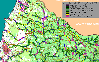
This image shows riparian vegetation as derived from a 1994 Landsat image by the USFS Spatial Analysis Lab in Sacramento. The coverage is accurate at the one hectare scale and was queried for tree size in the KRIS Noyo Map project as an indicator of seral stage. A 90 meter buffer adjacent to streams (1:24000 USGS) was clipped to analyze riparian conditions in the Noyo River. Much of the riparian zone of Pudding Creek and its tributary Little Valley Creek have non-forest and saplings (trees <5" diameter) as dominant components. Click on the InfoLinks tab for more information about the derivation of the image in the KRIS Noyo Map project.
 Click on image to enlarge (95K).
To learn more about this topic click here
| www.krisweb.com |
