| Area | Lower Noyo/Basin-wide |
| Topic | Tour: Historical Photos Lower Noyo and Estuary |
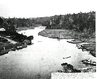
Lower Noyo River circa 1863 looking upstream. "Fishing wheel shows at foot of road. Trestle carried water line from waterfall gulch to the mill, crossing under the river. The ferry shows lower right. Dodge store shows on road." This early shot of the Noyo gives some indication of pre-disturbance estuarine conditions. Note sloughs branching off to the right. No record of fish species caught in early fishing is available, but the fish wheel indicates that early settlers harvested salmon from the river. It is possible that the Noyo held chinook salmon as well as coho prior to disturbance. Because chinook use estuaries for rearing, the loss of this habitat due to sedimentation as well as disruption of mainstem spawning habitat could have eliminated them. Courtesy Held-Poage Historical Library, Ukiah. - Robert J. Lee Collection. Wilder (01109).
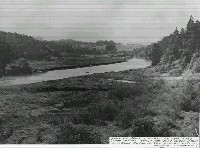
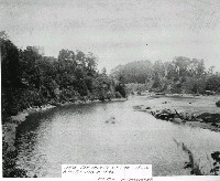
Photo of the Noyo River estuary, probably circa 1860's. "Looking downstream on the Noyo at what will become the mooring basin in the distant future." This picture shows the Noyo River estuary in pre-disturbance conditions. Courtesy Held-Poage Historical Library, Ukiah. Robert J. Lee Collection.
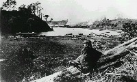
"Noyo Mill-Althea Hazeltine-the photographer's daughter in the foreground. Photo taken in late 1860's or early 1870's" Note that the Noyo estuary is still extensive, prior to major sediment pulse from early logging. Courtesy Held-Poage Historical Library, Ukiah. Robert J. Lee Collection. Escola: 01113.
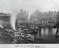
"The Noyo Mill about 1880 with a schooner tied in." This suggests that sedimentation of the estuary from early logging had not yet taken place as schooners were able to traverse the river bar. Courtesy Held-Poage Historical Library, Ukiah. Robert J. Lee Collection. Watkin photo, Bencroft Library, U.C., per S.F Maritime Museum: 01116.
"Near the mouth of the Noyo River-Circa 1895." The photo is looking downstream and shows a substantial build up of sediment at right, probably as a result of erosion triggered by early logging. Courtesy Held-Poage Historical Library, Ukiah. Robert J. Lee Collection. McFarland: 01124.
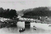
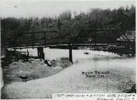
Land forms suggest that this photo is at the same location as Picture #1 but with a zoomed in view. Small dwellings or fishing shacks to the right are in areas that appeared as marshes and sloughs in the earliest photo but also hotel which is now missing. Logging has taken place on the hillslope at right. "An early view of the Noyo River and Bridge. P.O. date June 25, 1913. White and Plummer store shows." Courtesy Held-Poage Historical Library, Ukiah. Robert J. Lee Collection. Keller: Escola: L-01122.
"Postcard view-Postal date Oct. 18, 1904." Bridge design suggests that this photo is from the same location as Picture #2. Note that the point bar extends to the middle of the bridge span, although the difference between this and Picture #2 could be tide height. The postal dates suggests that this picture is from a slightly earlier period (1904 vs. 1913) but the photo dates for each are unknown. Silva: 04414. Courtesy Held-Poage Historical Library, Ukiah. Robert J. Lee Collection.
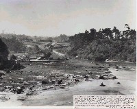
"Looking South toward back of White and Plummer store with the second bridge beyond. Tidal flat in foreground is to become the Noyo Flat after a barrier is built along river channel and dredged material is deposited behind it." Date of photo is unknown but likely 1890-1910. The "flat" in the photo is likely a result of sediment build up from early logging. Courtesy Held-Poage Historical Library, Ukiah. Robert J. Lee Collection. Racine: 01123.
 Click on image to enlarge (89K).
 Click on image to enlarge (87K).
 Click on image to enlarge (90K).
 Click on image to enlarge (84K).
 Click on image to enlarge (86K).
 Click on image to enlarge (72K).
 Click on image to enlarge (138K).
 Click on image to enlarge (87K).
To learn more about this topic click here
| www.krisweb.com |
