

|
Area/Topic | Bibliography | Background | Hypotheses | Home |
|
Map Page.
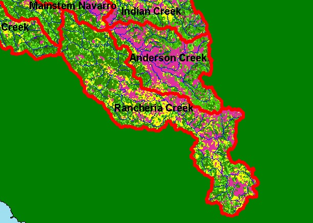
You selected the area Rancheria Creek and the topic Map: 1F USFS Vegetation Size, Rancheria Creek Sub-basin |
| This is a map of 1994 Landsat derived vegetation size data in the Rancheria Creek sub-basin, displayed with USGS 1:100,000 scale streams. Early seral stage conditions represented by widespread areas in the northwest and northeast of the sub-basin with small diameter trees indicate recent, active timber harvest. Data provided by the U.S. Forest Service Pacific Southwest Region Remote Sensing Lab, Sacramento, CA. Scale = 1:280,482 . | |||
|
|
||
To view metadata about a map layer, click on a link in the table below.
| Name of Layer in Map Legend | Metadata File Name |
|---|---|
| Sub-basins (w/ labels) | subbasins.shp.txt |
| Project Frame | Unavailable |
| Streams (1:100k scale)(no labels) | streams100.shp.txt |
| USFS Riparian Veg Size | vegsizebuf.tif.txt |
| USFS Vegetation Size | vegsize.tif.txt |
| Topo Map (1:24k scale) | Unavailable |
| Graycale Hillshade (TIFF) | grayscale_xnv_light.tif.txt |
| Project Background | Unavailable |
| www.krisweb.com |