
| Area | Geyserville |
| Topic | Habitat: Habitat Types by Length in Middle Geyserville Tribs 1998-2001 |
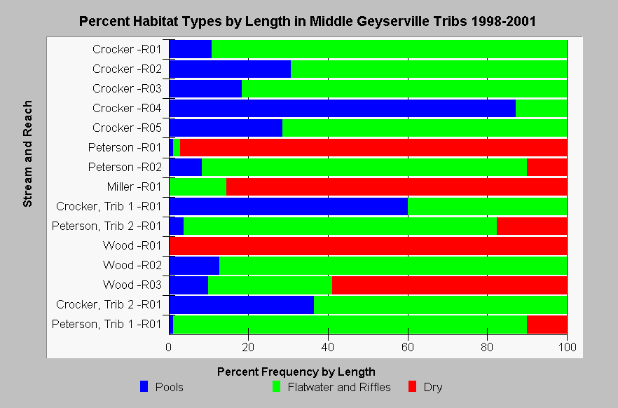
| Caption: This chart shows a summary of habitat types by length from California Department of Fish and Game (CDFG) habitat typing surveys in streams in the middle portion of the Geyserville sub-basin in 1998 and 2001. Streams in the chart are sorted by Strahler order (with larger streams at the top), and reaches are numbered upstream beginning at stream mouths. Crocker Creek reach four and Crocker Creek Trib 1 were the only two reaches that contained at least 40% pools by length. CDFG stream survey reports state, "In general, pool enhancement projects are considered when primary pools comprise less than 40% of the length of total stream habitat." Some reaches in Peterson, Miller, and Wood were mostly dry. Riffles and flatwater are combined in this graph because CDFG reach summaries did not separate them. See InfoLinks for more information. | |
 |
To learn more about this topic click Info Links .
To view additional information (data source, aquisition date etc.) about this page, click Metadata .
To view the table with the chart's data, click Chart Table web page.
To download the table with the chart's data, click hab_cdfg_gy_midtribs_98_01.dbf (size 20,916 bytes) .
To view the table with the chart's source data, click Source Table web page.
To download the table with the chart's source data, click hab_cdfg_rus_94_01_source.dbf (size 299,436 bytes)
| www.krisweb.com |