LOST RIVER
WATERSHED AREA IN CALIFORNIA
(TRIBUTARY TO KLAMATH RIVER)
WATER QUALITY CHARACTERISTICS
PREPARED BY
STAFF
William D. Winchester
Rhonda L. Raymond
Susan D. Tickle
OF THE CALIFORNIA REGIONAL WATER QUALITY CONTROL BOARD
NORTH COAST REGION
September 29, 1995

CONTENTS
Introduction
Results and Discussion
Conclusions and Recommendations
Bibliography
Appendicies
INTRODUCTION
Lost River is a unique bi-state stream flowing along the California-Oregon
border (Figure 1). The headwaters of Lost River are tributaries to Clear
Lake located mostly in Modoc County, California. The outflow from Clear
Lake into Lost River flows north into Oregon and then loops back south
into California where it historically ended in a closed sump known as Tule
Lake. A large U.S. Bureau of Reclamation (BOR) agriculture project known
as the Klamath Project has been constructed in this watershed, and has
significantly altered the flows and flow direction of Lost River. The Lost
River is now cross connected with the Klamath River through a constructed
canal and drain system in Oregon. Water in the Lost River flowing south
back into California may now be a combination of Lost River and Klamath
River water depending on the time of year. Tule Lake is no longer a closed
sump. The BOR has constructed pumps to move water from Tule Lake west into
Lower Klamath Lake. Lower Klamath Lake then discharges north back into
Oregon through the Klamath Straits Drain. This drain then flows northward
and is pumped back into the Klamath River in Oregon. The Klamath River
then continues in its south-west direction downstream back into California.
As the Lost River makes its journey described above, its natural and
altered environmental characteristics change dramatically. It begins as
high desert streams tributary to Clear Lake located mostly in Modoc National
Forest. Boles Creek and Willow Creek are the principal tributaries. These
streams and Clear Lake, as does the rest of the watershed down to Tule
Lake, support fisheries. These include two species of federally listed
endangered sucker species, the Lost River sucker and the shortnose sucker
(Federal Register, 1994). The principal nonpoint source discharge influences
in this part of the watershed are from rangeland cattle grazing. This has
been recognized in the Modoc National Forest Land and Resource Management
Plan (Modoc National Forest, 1991), and is a focus of the North Coast Regional
Water Quality Control Board's Clean Water Act 319(h) nonpoint source control
program working with Modoc National Forest, Lava Beds Resource Conservation
District (RCD), and the U.S. Fish and Wildlife Service (USFWS). Clear Lake
is also part of the Clear Lake National Wildlife Refuge.
Lost River, a short distance downstream from Clear Lake, enters the
State of Oregon where its use as a source of water and also drainage for
agriculture begins. Agriculture primarily includes grains, hay and forage,
and potatoes. By the time it once again re-enters California just north
of the town of Tulelake, it has been influenced by nonpoint source discharges
from production agriculture, water imports or exports, and channel modifications.
Lost River habitat characteristics become a shallow lake/wetland type of
habitat soon after it enters California and flows into Tule Lake. Tule
Lake is highly eutrophic (Boyer, 1994). Some natural levels of eutrophic
conditions and poor water quality can be expected in this area because
of the fact that historic conditions found this area to be a vast sink
(lakebed/marshland) of biomass propagated by nutrient-rich "recent " volcanic
formations. This reservoir of biomass has become the soil of today's basin.
Eutrophic conditions remain the principal water quality concern in this
area. The water quality questions are 1) to what extent these eutrophic
conditions are natural, 2) to what extent nonpoint source discharges from
agricultural activities impact this situation, and 3) what is the water
quality significance of these nonpoint source discharges, if any. These
eutrophic conditions remain as the water is pumped and flows through Lower
Klamath Lake and into Klamath Straits Drain north back into Oregon. Both
Tule Lake and Lower Klamath Lake are part of the National Wildlife Refuge
system.
California's water quality concern again starts at the California -
Oregon border downstream in the Klamath River. The question here is whether
the water quality conditions in the Klamath River at this point can be
correlated to water quality in the Lost River watershed, and specifically
to nonpoint source discharges into the Lost River system in California.
California has no authority to investigate water quality in Oregon, but
is working with Federal and State agencies in Oregon to coordinate our
monitoring efforts and better delineate sources of concern.
RESULTS AND DISCUSSION
Water Quality MonitoringNorth Coast Regional Board staff monitored water
quality parameters in the lower Lost River watershed during 1992-1995.
This monitoring focused on nutrients, heavy metals, general ionic minerals,
and physical parameters, and also included pesticide and herbicide monitoring
in the Tulelake area. Pesticide and herbicide data can be found in Regional
Board files and staff reports (Winchester, 1994) located in the Regional
Board's office in Santa Rosa. These pesticide and herbicide data raised
no significant water quality issues of concern for the Regional Board.
The monitoring for the other chemical and physical parameters are the data
presented in this report. All samples collected were "grab" samples collected
in accordance with Regional Board protocol. Analyses for water and air
temperature, specific conductance, pH, and dissolved oxygen were performed
in the field by Regional Board staff, with assistance at times from staff
of the Tulelake Irrigation District. All other samples were sent to contract
laboratories for analyses.
The primary emphasis of this monitoring was oriented towards attempting
to gain more knowledge about the role of nonpoint source discharges from
agriculture in California on the water quality in the lower Lost River
watershed in California. The focus has been on eutrophic conditions. The
narration of this report is intended to deal primarily with eutrophic conditions,
but other water quality data is also shown in Appendix A, for reader information,
as collected during the same time period by Regional Board staff. This
additional data will be analyzed in future reports after more data is available.
Additionally, we have included in this report limited data collected in
the Klamath River at the California - Oregon border to show any general
correlation that may exist from this point and the Lost River watershed
upstream.
This report is prepared with data collected by Regional Board staff
available to us by mid-June, 1995. The amount of data is limited, but is
being presented here for use by interested parties. An on-going, more intensive
monitoring effort has been implemented for the summer of 1995 with Regional
Board student help from the College of the Siskiyous funded through U.S.
Environmental Protection Agency Clean Water Act Sections 319(h), 604(b),
and 104(b) grant funds. There is also increasing coordination and sharing
of monitoring efforts among the two States and Federal agencies in 1995.
Figure 1 also shows monitoring station locations and station name acronyms.
All data is presented in Appendix A. For ease of reader interpretation,
selected data is presented in bar graph format at individual stations and
also at stations generally moving down through the watershed areas. Due
to the fact that some of the stations around the Tule Lake Sumps are not
actually "downstream" of one another because of regulated water movement
through the basin, care must be taken when interpreting the graphs to not
conclude otherwise.
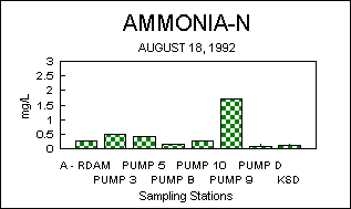
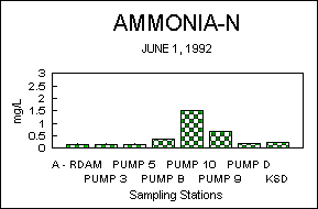
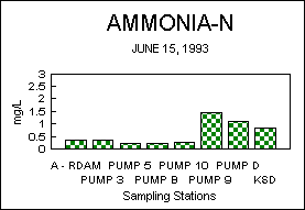
NH3-NTotal Ammonia-Nitrogen (NH3-N)
Total ammonia-nitrogen (NH3-N) can be found in the Lost River system
likely from several different primary sources. It can be originating from
Klamath River water diverted into the Lost River below Upper Klamath Lake
during the irrigation season, it can be formed by the chemical and bacterial
decomposition or breakdown of animal wastes or natural organic material,
from resuspended bottom sediments, or it can be introduced as a crop fertilizer.
Without knowledge from a study designed specifically to identify nitrogen
sources in a specific area, the shallow eutrophic waters of Tule Lake and
Lower Klamath Lake receiving imported water and agricultural drain water
make for an endless scenario of possibilities as to the primary origins
of a given NH3-N concentration found at any one particular point in time.
This makes data from a set of monitoring stations located throughout the
watershed difficult to interpret unless overall consistent seasonal NH3-N
concentrations are found at stations or an obvious trend between stations
is observed over time.
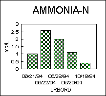
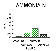
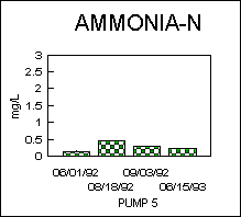
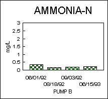
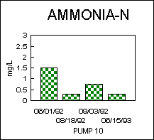
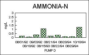
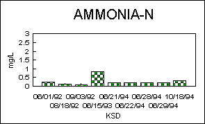
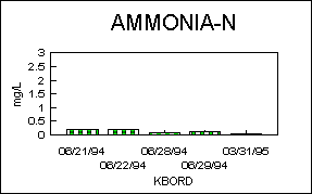
Figures 2 and 3 display NH3-N concentrations. Lost River at the California-Oregon
border (station LRBORD) consistently exhibited the highest NH3-N concentrations.
Tulelake Irrigation District pumps 3, 10, 9, and D around Tule Lake exhibited
higher concentrations than most other stations (except LRBORD on most sampling
dates) on different sampling dates, but show no trend between stations, and
no correlation with results from Anderson Rose Dam, the diversion point for
Lost River water into the Tulelake area. This suggests the multiple sources
of NH3-N as described above. Maximum and minimum NH3-N concentrations at all
stations ranged from a high of 2.6 mg/L at station LRBORD to a low of .025 mg/L
at station KBORD.


Un-ionized Ammonia
Un-ionized ammonia can be toxic to aquatic life at low concentrations.
USEPA has established a national criterion for un-ionized ammonia concentration
for the protection of aquatic life at .025 mg/L. The percent of this toxic
un-ionized form of the total ammonia-nitrogen present increases with increased
water temperature and/or increased pH level. During the summer period,
the lower Lost River system exhibits both high water temperatures and very
high pH. The high pH results partly from photosynthetic activity from the
highly eutrophic conditions. Recent U.S. Department of the Interior studies
(MacCoy, 1994) of the Klamath Project area found high levels of un-ionized
ammonia in the lower Lost River system. Regional Board staff discussions
with U.S. Fish and Wildlife officials (Schwarzbach S., personal communication,
1994) involved in the study found that they concluded that un-ionized ammonia
may be the most consistently toxic material for aquatic life in this area.
Figures 4 and 5 display un-ionized ammonia concentrations. These un-ionized
ammonia concentrations were calculated by formula presented in Emerson,
1975 and shown in Appendix A. The national criterion of .025 mg/L was exceeded
on some sampling dates at all sampling locations. The highest concentrations
were at the Tulelake stations at Pumps 9, 10, and D. Maximum and minimum
un-ionized ammonia concentrations at all stations ranged from a high of
.613 mg/L at station Pump D to lows of 0.0 mg/L at numerous stations at
one time or another.
Total Kjeldahl Nitrogen (TKN)
Total Kjeldahl Nitrogen (TKN) is the total of the organic and ammonia
nitrogen. Lost River water high in organic material such as algae for instance
can be expected to have high TKN concentrations regardless of ammonia-nitrogen
concentrations. TKN and other nitrogen concentrations reported here should
strongly reflect that elemental nitrogen resides, in great mass, within
the soils of the sedimentary reservoir of the lower Lost River watershed,
and is continuously being oxidized and reduced by living organisms.
Figures 6 and 7 display TKN concentrations. Maximum and minimum TKN
concentrations at all stations ranged from a high of 7.80 mg/l at station
KSD to a low of .25 mg/L at station KBORD. A review of these TKN values
show no trend over time at any given station or between stations. A comparison
of TKN values with NH3-N values shown above show that the majority of the
TKN value is normally from organic nitrogen.
Nitrate (NO3)
Ammonia in surface water will oxidize to nitrite (NO2) and then to
nitrate (NO3). NO3 is a plant nutrient and depending on conditions can
cause nuisance algal blooms and excessive aquatic vascular plant growth.
This in turn can suppress dissolved oxygen levels and increase pH levels
to the detriment of fish and other aquatic life. The North Coast Regional
Board's Water Quality Control Plan for the North Coast Region (Basin Plan)
(1994) sets narrative objectives for biostimulatory substances. The Basin
Plan specifies that "Waters shall not contain biostimulatory substances
in concentrations that promote aquatic growths to the extent that such
growths cause nuisance ar adversely affect beneficial uses". Numeric objectives
for these nutrients have not been established for Lost River.
Figures 8 and 9 display NO3 concentrations. Maximum and minimum NO3
concentrations at all stations ranged from a high of 1.44 mg/L at station
KSD to a low of .015 mg/L at numerous stations at one time or another.
No obvious trends or correlation over time or between stations can be seen
with the data collected. Additionally, there is no obvious consistent correlation
between NH3 and NO3 comparing all stations.
Total Phosphates (TPO4)
Phosphorus, as total phosphates (TPO4), can be a nutrient for algae
and vascular aquatic plant growth as NO3 above. The inorganic dissolved
form of phosphorus is orthophosphate (OPO4). This OPO4 form is the most
readily available form of phosphorus for algae to use. For the data collected,
both organic and inorganic phosphorus contibuted to the total phosphorus
concentrations monitored, with OPO4 generally contributing the major portion.
Figures 10 and 11 display TPO4 concentrations. Maximum and minimum TPO4
concentrations at all stations ranged from a high of 1.2 mg/L at station
KSD to a low of .025 mg/L at several stations in October, 1994.
As with the other water quality constituents monitored above, TPO4 showed
no obvious trends over time or correlations between stations. This again
suggests multiple sources and environmental factors are significantly responsible
for nutrient levels in the lower Lost River watershed.
Dissolved Oxygen (D.O.)
Eutrophic water conditions such as those which exist in the lower Lost
River system can often result in low dissolved oxygen (D.O.) conditions.
The Basin Plan water quality objectives for D.O. specifies a minimum concentration
of 5.0 mg/L for the Lost River and 7.0 mg/L for the Klamath River above
Iron Gate Dam for the protection of aquatic life.
Figures 12 and 13 display D.O. concentrations. Maximum and minimum D.O.
concentrations at all stations ranged from a high of 14.2 mg/L at station
LRBORD on May 18, 1995 to a low of 2.2 mg/L on June 29, 1994 at the same
station.
The minimum D.O. objective of 5.0 mg/L for the Lost River was not met
at one time or more at seven of the ten stations monitored. These readings
were all taken during the daytime hours when higher diel D.O. levels are
expected to occur. As above with other water quality parameters, the D.O.
data collected exhibits sporatic concentrations both over time and between
stations. This illustrates that multiple factors among sites are likely
responsible for water quality conditions at any one point in time.
The Oregon Department of Environmental Quality has found that the Klamath
River in Oregon from Upper Klamath Lake to Keno routinely violates their
D.O. standard of 5.0 mg/L (Baumgartner, 1994). The North Coast Regional
Board's Basin Plan minimum D.O. objective of 7.0 mg/L for the Klamath River
in California above Iron Gate Dam was met for station KBORD for the dates
and time collected.
Additionally, BOR Klamath Project staff (Berg, M., personal communication,
1995) has told us that BOR has a significant amount of diel water quality
data, including D.O. measurements, from this area. Regional Board staff
will be reviewing this with BOR staff in the future to get an idea of algal
production and Biochemical Oxygen Demand in the Lost River watershed in
California.
pH
pH is a measure of the hydrogen ion activity in water. High photosynthetic
activity in eutrophic waters can result in high pH levels. The North Coast
Regional Board's Basin Plan specifies water quality objectives for pH in
the Lost River to be a minimum of 7.0 units and a maximum of 9.0 units.
pH objectives for the Klamath River above Iron Gate Dam are a minimum of
7.0 units and a maximum of 8.5 units.
pH concentrations are displayed in Figures 14 and 15. All Lost River
stations except for station JCBORD did not meet Basin Plan minimum and/or
maximum pH objectives at one time or another. Maximum and minimum pH levels
at all stations ranged from a low of 4.6 at station KSD to a high of 10.2
on two dates at station Pump D. pH levels are consistently high throughout
the lower watershed, and are particularly high over time at the Tule Lake
station Pump D. In bioassay tests, juvenile sucker mortality has been observed
at pH values of 10 or more. pH levels of 10 or more were observed on three
sampling dates at station Pump D.
Bureau of Reclamation diel pH data from the Lost River system needs
to be reviewed as mentioned above to better understand diel pH fluctuations
and how long these higher levels are sustained over a day or other time
period.
Specific Conductance
Specific conductance is a measure of the ionized or dissolved minerals
in water. Basin Plan water quality objectives for specific conductance
for the Lost River Hydrologic Unit are shown in Table 1. The data presented
in this report are not enough to meaningfully compute monthly means for
a calendar year for these objectives. We can however make general observations
regarding specific conductance levels.
It is normally expected that ionized salts as measured by specific conductivity
will increase through an agricultural area as soils are leached and water
used and evaporated. Any number of other reasons in this area for an increase
in ionized salts can include ground water inflow and spring activity, and
surface evaporation from the large shallow lakes.
Specific conductance levels are displayed in Figures 16 and 17. As expected,
an increase in specific conductivity levels is observed as water flows
through the lower Lost River system. Highest levels were found during June,
1994 at station KSD. Maximum and minimum specific conductance levels at
all stations ranged from a high of 1,548 micromhos/cm (umhos/cm) at station
KSD to a low of 190 umhos/cm at station KBORD.
A review of BOR Klamath Project data for specific conductance levels
through the Lost River system will likely give us a better idea about these
specific conductance levels regarding any relationships with irrigation
practices and movement of water.
Water Temperature
The nutrient cycles and productivity impacts discussed above are accelerated
with warmer water temperatures. The slow moving, shallow waters of the
lower Lost River system combined with hot summer air temperatures makes
for very warm water temperatures.
Water temperatures are displayed in Figures 18 and 19. Water temperatures
throughout the lower Lost River system commonly exceeded 20 degrees Centigrade
(C) throughout the summer months. Maximum and minimum water temperatures
at all stations ranged from a high of 27.5 degrees C at station KSD to
a low of 8.0 degrees C at station LRBORD. In the Klamath River at station
KBORD, a high of 20.1 degrees C was recorded on June 29, 1994. Water temperatures
had dropped substantially in the lower Lost River system by the October
18, 1994 sampling run.
CONCLUSIONS AND RECOMMENDATIONS
The data presented in this report substantiate previously collected
data from other agencies and parties in the Lost River system. The lower
Lost River system in California exhibits very high summertime levels of
un-ionized ammonia, pH, and water temperatures, and low dissolved oxygen
levels. How these conditions are related to nonpoint source discharges
in California are complex and remain unclear to Regional Board staff. As
the California State agency charged with the control of water pollution,
it is becoming clear to us that three very specific water quality studies
need to be completed as follows:
1) California at times receives water of poor quality in the Lost River
and its distribution system from Oregon. The changes in water quality from
this point to the Klamath Straits Drain where California then discharges
this water back to Oregon are complex and varied. Regional Board staff,
in reviewing the data above and from other sources in the context of controllable
waste discharges, recommends a site-specific investigation into the issue
of high un-ionized ammonia levels. The contribution of ammonia from site-specific
fertilizer and irrigation practices and subsequent nonpoint source discharges
need to be documented in the Tule Lake basin. The University of California,
Davis and Intermountain Research and Extension Center has begun work on
this issue (Kaffka, et al., 1995).
2) A correlation, if any, between water quality discharged from the
Klamath Straits Drain and water quality in the Klamath River at the California-Oregon
state line needs to be investigated. California obviously contributes to
water quality conditions in the Klamth Straits drain. California's contribution
to this correlation, if any, needs to be a part of this investigation.
The best avenue for proceeding with a complex investigation such as this
may be a joint effort on the part of both States and irrigation interests
through the Clean Water Act Section 205(j) grant program and/or Total Maximum
Daily Load process.
3) Regional Board staff recommends coordination with BOR Klamath Project
staff for a review of BOR flow data and Datasonde diel data to look at
flow/water quality relationships. This is important since water import/export
through the lower Lost River system is likely a significant factor in the
variations in data observed above for this report. Once this is better
understood over time, it could possibly lead to improved timing of water
flow for water quality benefits, i.e. flushing refuge cell areas of poor
water quality during the fall and winter of wet years.
For data compilation, organization, and interpretation, the North Coast
Regional Board should continue to support the Klamath Restoration Information
System (KRIS) funded through the Clean Water Act Section 319(h) grant program.
Additionally, the North Coast Regional Board should continue to support
stream restoration and rangeland grazing nonpoint source control efforts
on the part of landowners, Lava Beds RCD, Modoc National Forest, and the
USFWS in the upper Lost River-Clear Lake watershed through the Clean Water
Act Section 319(h) grant program.
BIBLIOGRAPHY
Baumgartner, B. June 6, 1994. Oregon Department of Environmental Quality
Memorandum.
Berg, Mike. U.S. Bureau of Reclamation Klamath Project. Personal communication.
1995.
Boyer, R. and C. E. Grue. 1994. Water Analyses for Agrochemical Input
at Tule Lake National Wildlife Refuge. University of Washington. Prepared
for the U.S. Bureau of Reclamation. 41 pp.
Emerson, K., R.C. Russo, R.E. Lund, and R.V. Thurston. 1975. Aqueous
Ammonia Equilibrium Calculations: Effect of pH and Temperature. J. Fish.
Res. Board Can. 32(12): 2379-2383.
Federal Register. December 1, 1994. 50 CFR Part 17. Endangered and Threatened
Species: Lost River Sucker, etc.; Proposed Rule. Pages 61744-61759.
Kaffka, S.R., T.X. Lu and H.L. Carlson. 1995. An Assessment of the Effects
of Agriculture on Water Quality in the Tulelake Region of California. University
of California, Intermountain Research and Extension Center. 85 pp.
MacCoy, D.E. 1994. Physical, Chemical, and Biological Data for Detailed
Study of Irrigation Drainage in the Klamath Basin, California and Oregon,
1990-92. 168 pp.
Modoc National Forest. 1991. Land and Resource Management Plan. Pages
3-34 - 35.
North Coast Regional Water Quality Control Board. 1994. Water Quality
Control Plan for the North Coast Region.
Schwarzbach, Steve. U.S. Fish and Wildlife Service, Sacramento, CA.
Personal communication. 1994.
Winchester W.D. September 14, 1994. North Coast Regional Water Quality
Control Board Memorandum.